檔案:Corrientes-oceanicas.png
跳至導覽
跳至搜尋

預覽大小:800 × 418 像素。 其他解析度:320 × 167 像素 | 640 × 334 像素 | 1,000 × 522 像素。
原始檔案 (1,000 × 522 像素,檔案大小:75 KB,MIME 類型:image/png)

|
File:Corrientes-oceanicas-en.svg是本檔案的向量版本。 如果品質不低,就應該優先使用該檔案,而非PNG檔案。
File:Corrientes-oceanicas.png → File:Corrientes-oceanicas-en.svg
更多資訊請參閱Help:SVG/zh。 |
 |
摘要
| 描述 |
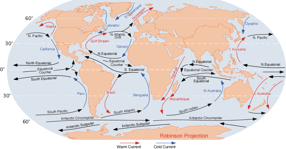
English: the ocean currents.
Note that
Finally, a few gyres also exist at the poles (not shown at this map); these are:
|
| 日期 | |
| 來源 | http://blue.utb.edu/paullgj/geog3333/lectures/physgeog.html, original image |
| 作者 | Dr. Michael Pidwirny (see http://www.physicalgeography.net) |
| 授權許可 (重用此檔案) |
Public domain. U.S. government publication. |
授權條款
此作品在美國屬於公有領域,因為其是由美國政府的官員或僱員,基於其個人公務目的製作的作品,參考美國法典第17篇第1章第105條。
注意︰本模板僅適用於美國聯邦政府的原創作品,不適用於任何美國州、屬地、聯邦個體、縣、市或任何次級政府的作品。本模板也不適用於1978年以後由美國郵政署出版的郵票圖案(參看美國版權局實踐綱領第313.6(C)(1)條)。也不適用於部分美國硬幣;參看美國鑄幣局使用條款。 |
 | |
| 此作品無已知的著作權限制,亦不受所有相關和鄰接的權利限制。 | ||
原始上傳日誌
| 日期/時間 | 大小 | 使用者 | 備註 |
|---|---|---|---|
| 2007年8月10日, 06:43:09 | 1000 × 522 (70712 bytes) | L30nc1t0 (留言 · 貢獻) | {{Information |Description=Imagen de las corrientes oceánicas mundiales. |Source=http://blue.utb.edu/paullgj/geog3333/lectures/physgeog.html |Date=Desconocido |Author=Desconocido |Permission=Desconocido. Entidad pública gubernamental estadounidense. |ot |
檔案歷史
點選日期/時間以檢視該時間的檔案版本。
| 日期/時間 | 縮圖 | 尺寸 | 使用者 | 備註 | |
|---|---|---|---|---|---|
| 目前 | 2014年12月3日 (三) 18:18 | | 1,000 × 522(75 KB) | GifTagger | Bot: Converting file to superior PNG file. (Source: Corrientes-oceanicas.gif). This GIF was problematic due to non-greyscale color table. |
檔案用途
下列2個頁面有用到此檔案: